As communities continue to grow and expand, developable land becomes more valuable. Parcels previously considered undevelopable are often viewed through a different lens. Floodplains are frequently an item of angst when developing, but that does not always need to be the case. Developing within a floodplain area presents unique challenges, but most of the time it is not an insurmountable task if approached thoughtfully. With proper planning, engineering, and coordination, a balance between development and flooding risks can be achieved. Before developing within a floodplain, it is important to understand the benefits of floodplains, how they are regulated, and what the process is to develop.
What Is a Floodplain?
A floodplain is an area adjacent to a river or waterbody that is subject to periodic flooding. These areas act as natural buffers, absorbing excess water during heavy rains and helping to prevent downstream flooding. Floodplains also provide vital habitats for wildlife, support agriculture, and offer recreational spaces for local communities.
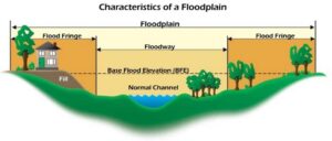
The Federal Emergency Management Agency (FEMA) works with state and local agencies, as well as private consultants, to study waterway systems to help identify areas that are at risk for flooding. Detailed studies for these waterways will help provide local communities and residents with more information regarding base flood elevations, location of the floodway, flow rates, and other helpful flood information.

Source: FEMA, National Flood Insurance Program Guidebook, 2009
A floodplain consists of both a floodway and flood fringe. Floodways are located along the main channel of a watercourse, which has been reserved for conveyance during the modeling of a specific reach. The delineation of a floodway is determined by the modeler of the stream using their engineering judgment of riverine systems based on how the conveyance of the floodwaters would behave in a storm event. Flood fringe is an area located within the floodplain but outside of the set floodway limits. Both floodway and flood fringe districts have their own set of regulations that originate back to the National Flood Insurance Program (NFIP) requirements.
Who Regulates Floodplains?
While FEMA is the overarching agency that regulates the NFIP, floodplains are administered by local government. The specific government official can vary between communities such as a Zoning Administrator, City Engineer, etc., depending on how the municipality is configured. Local communities that are part of the NFIP are required to have an ordinance consistent with NFIP standards. In Wisconsin, the Department of Natural Resources (WDNR) assists communities with floodplain regulations by providing a model ordinance that will help communities stay consistent with NFIP measures. Depending on the different types of floodplains within a specific community, the model ordinance can be tailored to best suit the local municipality.
What Are the Types of Floodplains?
There are many types of floodplains, which all have specific regulations associated with them. Below are a few of the common floodplain zones that are typically encountered:
- Zone A – an approximate floodplain zone without an elevation associated with it. Development cannot typically encroach on this zone.
 If development proposes to change grades within a Zone A floodplain, a base flood elevation will likely be required to be determined by completing an engineering analysis or detailed study of the area.
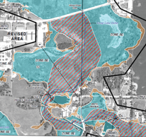
 - Zone AE (floodway or flood fringe) – a floodplain zone that was determined using a detailed study. Base flood elevations are associated with Zone AE and may often have a delineated floodway. If there is not a floodway delineated, an engineering analysis will likely be required to determine the location of the floodway.
- Flood Storage District – a district in which storage has been accounted for when generating stream flows for the detailed study. Storage districts are not found on FEMA’s maps but rather on local maps and can often get overlooked during the due diligence process. It is required for any proposed volume to be filled within the district to be provided elsewhere in the same hydrologic reach, otherwise known as compensatory storage.
How Can I Develop Within a Floodplain?
Before proceeding too far ahead with developing near or in a floodplain, it is always best to consult with a floodplain expert and the local community as soon as possible. Communities may have different permit processes and procedures for starting the development process.
More often than not, when developing in a mapped floodplain area, a Letter of Map Change (LOMC) will need to be acquired from FEMA to change the flood zone designation. There are a number of different LOMC’s that may be applied for depending on the specifics of the development:
- Letter of Map Amendment (LOMA) – a correction to a flood map based on better topographic information. A property may have been inadvertently mapped in the floodplain, while the property or structure may be above the base flood elevation. A property survey is required to be submitted with the LOMA. A LOMA will not change the
 effective floodplain mapping boundary, but it will provide documentation for lenders that states the property in question is out of the floodplain.
 - Letter of Map Revision (LOMR) – a revision to the effective floodplain mapping based on an engineering analysis. New floodplain studies, stream crossing replacements, and stream restoration projects are examples of projects that would require a LOMR. The effective floodplain mapping would be revised as part of the LOMR.
- Letter of Map Revision Based on Fill (LOMR-F) – a revision to the effective floodplain mapping based on filling of the effective floodplain, if it is filled to the flood protection elevation. An engineering analysis is required for this LOMC. In Wisconsin, the flood protection elevation is two feet above the base flood elevation. The effective floodplain mapping would be revised as part of the LOMR-F.
The LOMCs listed above may not apply to every development. It is important to consult a knowledgeable expert to help guide the process. In some cases, conditional letters are required to be obtained from FEMA before any construction can start. Conditional letters (CLOMA, CLOMR, CLOMR-F) are comments from FEMA stating the impacts of the development on the floodplain if it were constructed per the approved design. A conditional letter would need to be followed up with a LOMA/LOMR after construction.
Floodplain developments are complex and the regulations that are involved with them can be challenging. While this blog only scratches the surface on general floodplain topics, raSmith is here to help! We understand that there are critical timelines when developing a site, and our staff can help expedite the floodplain process through the appropriate channels. We have Certified Floodplain Managers (CFM) as well as the only Certified Floodplain Surveyor (CFS) in Wisconsin on staff who have worked through countless LOMCs with local communities, WDNR, and FEMA. Whether you have a small or complex floodplain project, contact our staff with any questions.
