Along a rural stretch of CTH H in Green Lake County, Wisconsin, nestled between farm fields, stands a roadside sign and monument marking the Center of Wisconsin’s Population. The sign and monument are located northwest of the city of Markesan, near Little Green Lake.
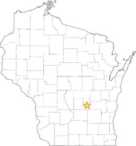
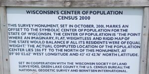
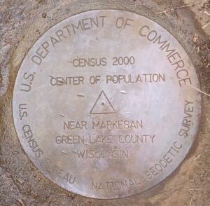
Photo of monument set in 2001
The sign and monument were constructed in 2001 (Wisc. Professional Surveyor No. 188, Dec. 2001) as part of a collaborative effort involving the Wisconsin Society of Land Surveyors (WSLS), Green Lake County, the National Geodetic Survey, Berntsen International (makers of the monument), and the U.S. Census Bureau. The monument was established as part of a surveyor’s outreach program to highlight the importance of land surveying, which plays a critical role in mapping Wisconsin’s landscape, defining property boundaries, and marking the locations for roads, highways, easements, and public parks.
The Center of Wisconsin’s Population is determined using geodetic coordinates published by the U.S. Census Bureau based on population distribution data. As the State’s population grows and people move, the center of population moves accordingly. Utilizing the published data from the past three censuses, our center of population has moved approximately 1.57 miles west and south. This movement corresponds to population growth in cities and towns from the center of the State to the west.
This trend aligns with the movement of the overall center of population for the United States, which, according to the U.S. Census Bureau, is currently located in Wright County, Missouri.
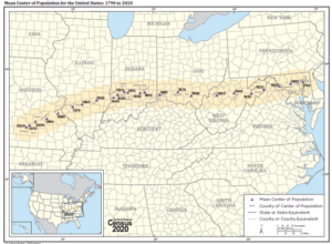
Center of Population of United States (from U.S. Census Bureau Website)